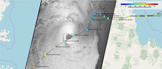
In March 2019, twin cyclones hit Australia. Tropical cyclone Trevor made landfall on Australia’s northern coast on March 23rd, bringing torrential rains and winds of up to 230km/h. Just two days later, another tropical cyclone, called Veronica, hovered off Australia’s northwest coast, causing heavy rainfall, large waves, and extensive flooding. From 700 km above, European Earth Observation satellites tracked the twin cyclones.
Since 2016, experts from IFREMER and CLS have organized, in collaboration with the European Space Agency (ESA), a campaign called SHOC (Satellite Hurricane Observation Campaign), in order to gather extreme wind observations from European spaceborne sensors. In collaboration with space agencies and meteorological institutes, IFREMER and CLS experts are able to track the paths of cyclones and other storms and characterize the associated ocean surface wind speed.
Tracking cyclones by satellite
The IFREMER/CLS team uses Copernicus data along with other higher resolution data from multiple commercial providers to deliver the highest measurement accuracy.
To do this, precise track forecasts available from World Meteorological Organisation (WMO) Regional Specialised Meteorological Centre are provided by IFREMER/CLS to ESA’s mission planning team when a cyclone starts to materialize. In return, ESA identifies and plans the most suitable Sentinel-1 observations intersecting the expected location of the hurricane’s eye over the next 5 days. Depending on both the evolution and duration of the phenomenon, updates on track forecasts are expected every 3 days and, consequently, the planning loop is repeated to capture the new trajectory. This strategy enables the team’s experts following hurricanes throughout their entire lifespan (from Category 1 and above), thanks to dedicated “late-programmed” Sentinel-1 acquisitions by ESA’s Mission Planning team.
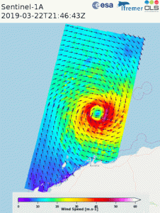
Copyright: Contains modified Copernicus Sentinel data (2019) The SAR images and wind maps are available for viewing on the EODA Portal, under the SHOC demo: eoda.cls.fr
Precise wind speed measurements from space
In the case of Trevor and Veronica, Ifremer transferred wind speed measurements to Australia’s Bureau of Meteorology. SAR wind speeds measured reached up to 50 m/s, which is slightly higher than what Australian meteorologists had analyzed using several existing measurements.
Having access to SAR that provides high resolution surface winds that are accurate at all intensities will boost the ability to estimate the intensity and size of stronger cyclones. This will lead to improved forecasts including storm surge forecasts that are heavily reliant upon intensity and size. In the case of Veronica, the SAR data provided confidence that the cyclone was as strong as our operational estimates at some stages, but for one pass SAR was higher than we expected. This presents a challenge, as if this verifies to be valid, it would make forecasters rethink the skill of traditional techniques and result in a higher intensity when it was close to the coast. Ideally this data could be available in real-time to be of greater help in the operational environment.