SAR-generated winds are providing a unique, high-resolution, view of tropical cyclones’ wind structure. Using other sensors and techniques with those winds helps in understanding the impact of such extreme events on the ocean. This with the aim of understanding the air-sea interactions and better forecast their intensity.
Observing Tropical Cyclones
Tropical cyclones are in close interactions with the ocean as well as with the atmosphere. In particular, a tropical cyclone’s wake is generally characterised by a cold surface anomaly, the storm having “fed” from the energy of the water upper layers’ heat. A better assessment of the impact on the ocean of a cyclone after its passing can help in estimating the potential of the ocean before. And thus helps in forecasting intensity of such phenomena in the future.
The CyclObs Archive center, one of the data access services available within CYMS, is proposing state-of-the-art and homogeneous cyclone datasets back to 2012. A more extensive list has been available since April 2014 (Sentinel-1A launch). Observations have been more systematic since Summer 2016, when the Satellite Hurricane Observation Campaigns (SHOC) began with activation of Sentinel-1 acquisitions over such events by ESA team. Copernicus Sentinel-1A & B provide reliable surface winds up to 70 m/s.
Comparing ocean data
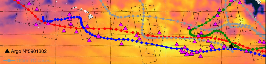
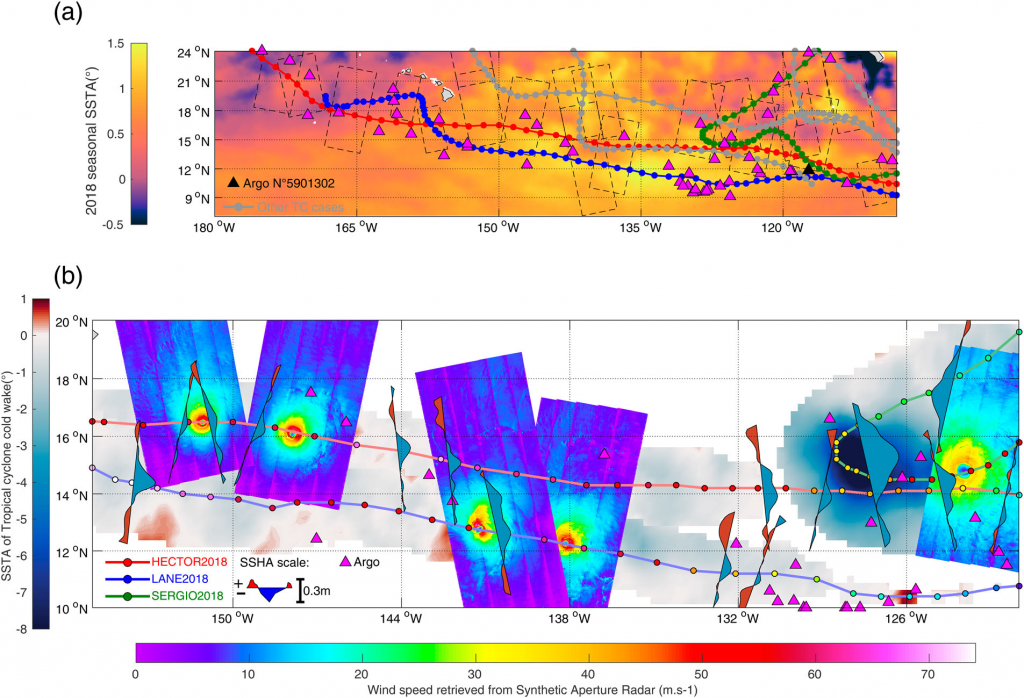
A study by Ifremer makes comparisons of the Tropical Cyclone best track of three of the 2018 Eastern Pacific Tropical Cyclones with ocean data available through the Copernicus Marine Service (CMEMS) and with SAR-estimated (Sentinel-1A & B) wind speeds. 2018 was a very active cyclonic season in the Eastern Pacific – possibly in link with the weak El Niño occurring that year, with high SST anomalies over the region.
The impact of the cyclones on the ocean upper layers were estimated using gridded Sea Surface Temperature and along-track Sea Surface Height satellite observations, and Argo floats in situ Temperature-Salinity profile measurements from the Copernicus Marine Service (CMEMS) catalogue.
Using those data, the intensity of the drop of temperature in the wake was estimated, as well as the lower sea level and the stratification modifications.
Hector, Lane and Sergio impact
Results show moderate signatures for Hector and Lane which moved rather quickly, with maximum thermal and height anomalies amplitude of −1.7° and −0.17 m, respectively. Sergio, a weaker storm but larger and moving more slowly, generated a stronger cooling and a deeper trough, with (> −7°C and −0.3 m). This leads to the conclusion that the intensity of the cyclone is not the only factor in estimating its impact on the ocean. The speed of its translation is also important, as well as its size. In particular, in these cases, Tropical Cyclone parameters provided by high resolution SAR-derived winds allow to explain the effect of those Tropical Cyclone on the sea surface temperature and the sea surface height.
Combining several data, at high and low resolution from different sensors, can thus help in analysing and monitoring extreme events, and interpret their imprints, such as the resulting strength of cyclone-induced mixing and upwelling.
Reference
Clément Combot, Yves Quilfen, Alexis Mouche, Jérôme Gourrion, Clément de Boyer Montégut, Bertrand Chapron, Jean Tournadre, 2020: Space-based observations of surface signatures in the wake of the 2018 Eastern Pacific tropical cyclones, In: Copernicus Marine Service Ocean State Report, Issue 4, Journal of Operational Oceanography, 13:sup1, s88–s91; DOI: 10.1080/1755876X.2020.1785097